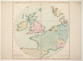
An Accurate Map of Great Britain, France & Ireland, with Part of Spain, Germany, Denmark &c. Showing at One View the True Bearing and Horizontal Distance, of any Place within 700 Miles of London; Drawn from the Best Authorities.
London: Laurie & Whittle, 1794. Map. Engraving with hand coloring.. Image measures 20 1/8" x 20 1/8". This unusual yet beautiful hemispherical projection of Western Europe is centered on London, such that the compass bearings are drawn as straight lines. The map has a 700 mile radius that encompasses the Faroe Islands, Bergen in Norway, Munich in Germany, Parma in Italy, the northern coasts of Majorca and Minorca, and Galicia in Spain. Countries, counties, and cities are all labeled. The..... More