
Victor Hugo: A Tumultuous Life.
337pp., tall 8vo, cloth-backed bds., d.w.; edgeworn & chipped. N.Y., (1971). More
337pp., tall 8vo, cloth-backed bds., d.w.; edgeworn & chipped. N.Y., (1971). More
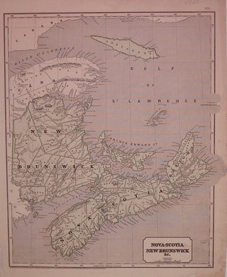
New York: Harper & Brothers, 1843. Map. Color wax engraving (cerograph). Image measures 14.75" x 12.25". Includes approach to the St. Lawrence River, the Bay of Fundy, and Prince Edward Island. A fine example of Sidney Edwards Morse's wax engraving technique, from "The Cerographic Atlas of the United States". Some wear to right edge. Sidney Edwards Morse (1794-1871) was an American geographer, journalist, and inventor. He shared his innovative spirit with his brother, Samuel F.B. Morse, and his father Jedidiah..... More
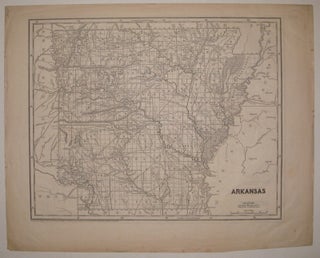
New York: 1842. Map. Uncolored wax engraving (cerograph). Image measures 11 7/8" x 15". A charming and rare map of Arkansas showing all counties, major towns, railroads and waterways. A fine example of Sidney Edwards Morse's wax engraving technique, from "The Cerographic Atlas of the United States". Map of Missouri on verso. Light scattered foxing, minor wear to edges. More
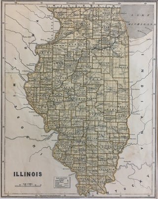
New York: Harper & Brothers, 1844. Map. Color lithograph. Image measures 14" x 11". This early graphic map of Illinois from 1844 shows much detail within the state borders, and labels Iowa, Missouri, Kentucky, and Indiana bordering it, as well as Lake Michigan. The counties are drawn and labeled and the state capital, county towns, canals, railroads, and common roads are labeled. Sidney Edwards Morse (1794-1871) was an American geographer, journalist, and inventor. He shared his innovative spirit with his..... More
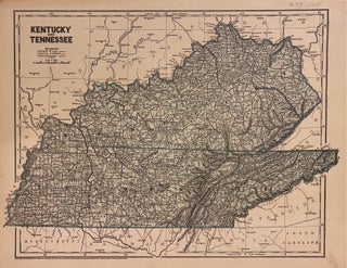
New York: Harper & Brothers, 1845. Map. Wax engraving (cerograph) with hand coloring. Image measures 16 3/4" x 12 1/4" This detailed map of Kentucky and Tennessee by Sidney Morse and Samuel Breese depicts the states divided into counties and townships. The map notes towns, roads, rivers, lakes, railroads, mountains, and other topography. This map was featured in Morse's North American Atlas, which, when originally published in 1842, was the first atlas of the United States to feature the technique..... More
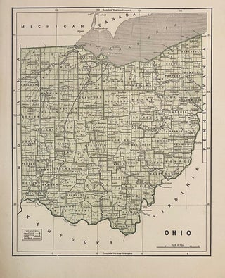
New York: Harper & Brothers, 1842. Map. Wax engraving (cerograph) with hand coloring. Page measures 12 3/8" x 16 1/4" This detailed map of Ohio by Sidney Morse and Samuel Breese depicts the states divided into counties and townships. The map notes towns, roads, rivers, lakes, railroads, mountains, and other topography. This map was featured in Morse's North American Atlas, which, when originally published in 1842, was the first atlas of the United States to feature the technique of cerography..... More
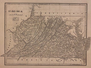
New York: Harper & Brothers, 1842. Map. Wax engraving (cerograph) with hand coloring. Page measures 12 3/8" x 16 1/4" This detailed map of Virginia by Sidney Morse and Samuel Breese depicts the states divided into counties and townships. The map notes towns, roads, rivers, lakes, railroads, mountains, and other topography. Map of Maryland and Delaware on verso, with an inset of District of Columbia, and an elevation view of the Chesapeake and Ohio Canal, and the Baltimore and Ohio..... More
First, I would like to wish you a Happy New Year! I hope you had the best holidays ever. I would like to thank you again and congratulate you for the great customer service you provide me. As you said, the book is in excellent shape and I am extremely happy with it. If in the future I wish to buy another book I will make sure to check with you first! Thanks again and all the best from Barcelona!
If there is a heaven, it looks a lot like your store. What a great place to spend an afternoon!