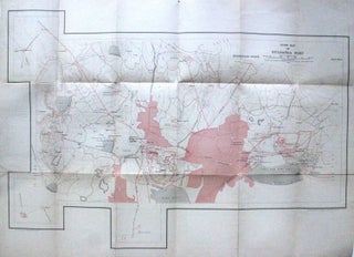
Guide Map of Gulbarga Fort
India: Survey of India, 1934. Colored offset Lithograph. Sheet maps 22" x 29.5". This 1934 pocket map depicts the plan of the Gulbarga Fort and vicinity located in the northern part of the state of Karnataka (at the time, Hyderabad State) in southern India. Beautifully detailed, the map notes the fort, important roads, lakes, wells, vegetation, and a host of other topographic elements. Originally built by Raja Gulchand, a feudatory of the Warangal Kakatiyas, it was further fortified and enlarged..... More
