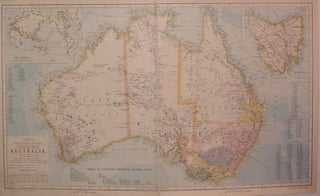
Statistical Map of Australia
London: Letts, Son & Co. Map. Color lithograph, mounted on linen. Image measures 16" x 26.75". Nicely detailed map of Australia, with paths of exploration, railroads and other landmarks. Includes insets of of Tasmania (known as Van Diemen Land until 1856), and the world with "distances from Australian ports". Lists of counties and distances between ports are scattered about page. From Letts's Popular Atlas, which was published 1881-1884. Only faint scattered foxing in margins. Thomas Letts (1803-1873) was an English..... More