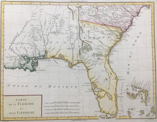
Carte de la Partie Septentrionale des Etats-Unis
Paris: Maradan, 1801. Map. Uncolored engraving. Image measures 14 1/4" x 19 3/4". Stains and foxing but otherwise in good condition. Important early map of the United States, published in "Voyage dans la Haute Pensylvanie et dans l'etat de New-York" by Michel Guillame de Crevecoeur. One of the most highly detailed and comprehensive maps published post-Revolution, it depicts the northeast US extending from Maine to northern Virginia, and westward to the Ohio River. In the Finger Lakes region, surveyed bounty..... More