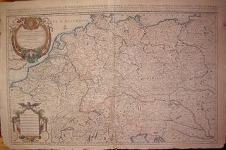
L'Empire d'Allemagne distingue suivant l'etendue de Touts les Estats, Principautes, et Souverainetes, qui passent ou qui ont passe jusque a present sous le nom d'Allemagne.
Amsterdam: Alexis-Hubert Jaillot, 1696. Map. Engraving with hand outline. Image measures 23" x 35". Stunning map showing the vast extent of the German Empire, including parts of Poland, Bohemia, Hungary, Austria, Croatia, Italy, France and the Netherlands. Exquisite and subtle coloring, beautifully detailed. Based on a plate by Nicolas Sanson, reworked and published in "Atlas Nouveau" by Jaillot. Severe toning due to early acid backing, chipping to edges and corners and some tears. Priced as is. Alexis-Hubert Jaillot (1632--1712) was..... More