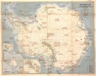
Antarctica
Washington, D.C. National Geographic Society, 1957. Map. Full-color lithograph. Sheet measures 23 3/4" x 21 1/2" Fascinating map of Antarctica. Highly detailed with notations describing the extent of international expeditions on the continent, with flags representing their respective stations. It features an Azimuthal Equidistant Projection executed by James M. Darly, Chief Cartographer, under the editor Melville Bell Grosvenor. Appeared in the September 1957 issue of National Geographic Magazine. This map is in good condition, with minor toning and wear along..... More