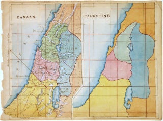
Canaan. Palestine.
Map. Pen and ink with watercolor. Image measures 7 x 8.5". This beautifully hand colored schoolgirl or schoolboy manuscript map of Canaan and Palestine (Israel or Holy Land) covers from Arish in northern Sinai north beyond Beirut. The Sea of Galilee and the Dead Sea are included. Essentially two maps on the same sheet, the left hand map depicts the region as it existed during Biblical times, when it was called Canaan. The Twelve Tribes of Israel are identified along..... More