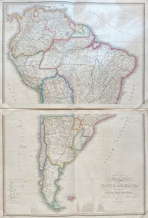
Colombia Prima or South America drawn from the Large Map in Eight Sheets
London: James Wyld, 1845. Map in 2 sheets. Engraving with original hand coloring. Each image measures 21.25" x 30.25, each page measures 23.5" x 32.25". This exquisitely detailed map was compiled from Louis Stanislas d'Arcy Delarochette's manuscript map of South America. Published shortly after independence movements swept the continent, liberating most the region from Spanish and Portuguese rule, the map shows few remnants of colonial holdings and is colored to represent newly established civil divisions. It also includes topographical profiles..... More