
Guide to Boatmanship, Seamanship, and Safe Boat Handling
Philadelphia: Chilton, 1960. Many photo Illus. 116pp. Small 8vo, tan cloth, d.w. slightly chipped. Philadelphia: Chilton, 1960. Very good. More
Philadelphia: Chilton, 1960. Many photo Illus. 116pp. Small 8vo, tan cloth, d.w. slightly chipped. Philadelphia: Chilton, 1960. Very good. More
Philadelphia: Abraham Small, 1824. xvi, 9-486 pages. 8vo, full contemporary mottled calf with black leather spine labels, lightly worn and soiled with toned pages and some foxing throughout. Philadelphia: Abraham Small, 1824. First Separate Edition. Very good. "A revision of the introductory portion of the author's, "Life of Washington." Howes M-316. More
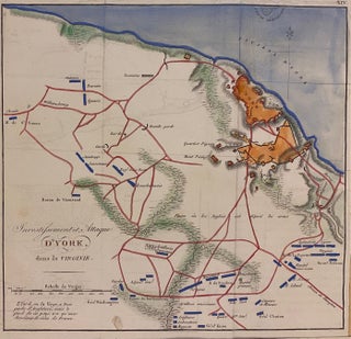
Paris: Dentu, Imprimeur-Libraire, 1807. Map. Engraving with hand-coloring. Image measures 8 1/2" x 8 1/2" Scarce Revolutionary War-era map of the battle of Yorktown in Virginia. Depicts the positions of the American and French regiments, including those of Gen. Washington, Gen. Knox, and Gen. Clinton, surrounding the British entrenchments along the York River. To contextualize the armies' paths, the map shows rivers, roads, swamp lands, and topography. Relief is shown by hachure. This map was published in the French version..... More
New York: Derby & Jackson, 1858. 379 pages. 8vo, contemporary grey cloth, decoratively gilt and embossed covers and spine. New York: Derby & Jackson, 1858. Heavy discoloration and toning to covers and page edges and internal foxing -- otherwise internally clean and tight. Good. More
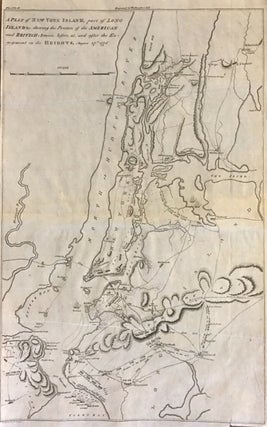
Philadelphia: C. P. Wayne, 1807. Map. Uncolored engraving. Sheet measures 17 x 10.5". This important and rare map of New York City and vicinity depicts the events surrounding the Battles of Long Island and Harlem Heights, which eventually led to the British takeover of New York and vicinity, and includes army positions and movements. Covers the theater of war in Manhattan, the Bronx, Brooklyn, Long Island, Queens, Staten Island, and parts of New Jersey. Land and sea position and movements..... More
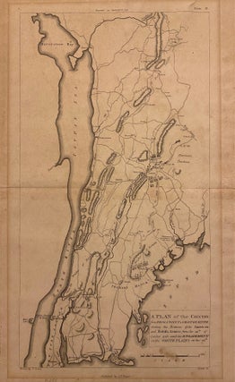
Philadelphia: C. P. Wayne, 1807. Map. Uncolored engraving. Sheet measures 17 3/8" x 11". This scarce 1807 Revolutionary War-era map extends from Harlem in Manhattan, New York City north as far as Croton-on-Hudson. Focusing on the strategic area on the west bank of the Hudson River, the map indicates the changing positions of the American and British armies from October 12 to 28, 1776 between Frog's Point to Croton River to eventually join the Battle of White Plains. The British..... More
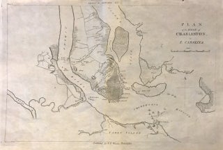
Philadelphia: C. P. Wayne, 1807. Map. Uncolored engraving. Sheet measures 10.5 x 16.25". This important 1807 Revolutionary War - era map depicts the Siege of Charleston, one of the major engagements fought during the War. It covers from the Shipyard south to include Charleston Harbor and vicinity, as well as parts of James Island and Sullivan's Island. After suffering losses in the north, the British shifted their attention to the Southern Colonies and seized Savannah and Charleston by 1779. The..... More
New York: George Gorman. Illus. 77pp. 8vo, blue cloth. New York: George Gorman, n.d. vg. More
Frontis. 44pp. 4to, cl.-backed bds.; (extremities worn). (Philadelphia), 1930. More
Philadelphia: J. Crissy, 1832. 10 double- page hand colored maps. Thin 8vo, original 3/4 brown cloth, paper label on front board, spine ends lightly worn, boards lightly soiled, offsetting to maps, fly leaf inscribed in ink otherwise in very good condition. Philadelphia: J. Crissy, (1832). Descriptive battle maps of the American Revolution. Printed to accompany the 1832 two-volume edition of Marshall's master biography of Washington. Howes M-317. More
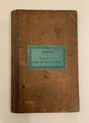
Philadelphia: J. Crissy, 1832. 10 double- page maps. Thin 8vo, original 3/4 brown cloth, paper label on front board, spine ends lightly worn, boards lightly soiled, a few maps have a rubber stamp from a previous private owner on the blank side and dampstains. First fly leaf inscribed in blue ink ' Rick N. Peterson May, 1844. Philadelphia: J. Crissy, (1832). Descriptive battle maps of the American Revolution. Printed to accompany the 1832 two-volume edition of Marshall's master biography of..... More
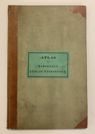
Philadelphia: Crissy, 1836. 2 volumes plus Atlas. Engraved frontispiece portrait of Washington in volume one. Atlas volume has engraved title page and ten maps outlined in color. iv, 460, 42, viii; 448, 32, v pages. 8vo. The 2 text volumes are bound in full contemporary polished calf with black spine labels (backstrips worn but sound); marbled edges and endpapers. Atlas bound in original 3/4 tan cloth and aqua boards with a paper title label on front cover (significant dampstaining. mostly..... More
Thank you very much for the fast delivery of my books. They were exactly in the condition you described and one of the volumes contained a very interesting dinner invitation and menu. Thank you very much, as well, for cost-effectively sending parcel via normal US Post.
The Colton map arrived today (5/11) and looks GREAT! It is a beautiful piece of work, and was securely packaged and protected. I really am pleased with your quick and friendly service -- and I am glad to make a purchase from a family run business!