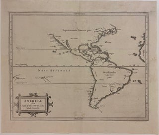
Americae sive Indiae Occidentalis Tabula Generalis
Amsterdam: 1630. Map. Engraving. 11" x 14". In very good condition. Expert wormhole repairs to margins and along original centerfold. Important map of the Americas published in 1630, considered the most accurate of the time. Coastlines and islands are labeled in great detail, including archipelagos in both the Atlantic and Pacific Oceans. Prioritizing accuracy over conjecture, Laet chose to omit the northwest United States from his map, avoiding the debate over the North West Passage. He also depicts California as..... More