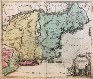
Nova Anglia Septentrionali Americae implantata Anglorumique coloniis florentissima
Nuremburg: Homann, Johann Baptist. Map. Engraving with hand coloring. Image measures 19 1/8" x 22.5". Early map of New England by Johann Baptist Homann dates to circa 1716. Extends from the Delaware Bay to Quebec and the St. Lawrence River and from Philadelphia east to Nova Scotia. Includes New York, New Jersey, all of New England and parts of Pennsylvania and Canada. The map notes American Indian as well as European settlements. Abound with interesting elements, the map is a...... More