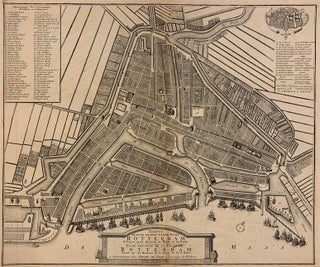
Nieuwe plattegrond van de stad Rotterdam
Henry de Leth, 1768. Map. Engraving. Image 16 1/8 x 19 1/4 inches. Striking plan of the port city of Rotterdam on the Maas River in the Dutch province of South Holland. Top left in a block is a legend with 76 main street buildings and, top right in cartouche the provincial coat of arms from Holland and the city arms of Rotterdam. Extensive repairs to center margin and gate 36. The Amsterdam publishing firm of Covens and Mortier (1665-c..... More