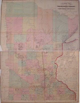
Sectional Map of the Surveyed Portion of Minnesota and the North Western Part of Wisconsin
Boston: J.S. Sewall, 1866. Case map. Engraving with original hand coloring. Image measures 32.5" x 24.5". Fantastic and rare map of Minnesota and part of Wisconsin divided into counties. Shows many townships, cities, major routes, waterways and Indian reservations. Originally a pocket map, now in two pieces with several repairs along folds. Creases and scattered chips, a few ink notations and light scattered foxing. Three holes along top from binding. Booklet is missing. More