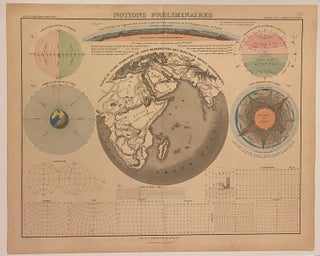
Notions Preliminaires
Paris: Chardon, 1838. Map. Engraving with original hand coloring. Image measures 16" X 19 3/8" This fascinating double-page engraving features several terrestrial globes with information on the geography and geology of the earth. Diagrams and models depict mapping projections, latitude and longitude lines, the Earth's interior, and topography. Jean Goujon ((1793-1826) worked for the Depot de la Guerre in Paris which made countless maps and plans. Goujon and Anddriveau were partners of Jean and his son, also cartographers and publishers..... More