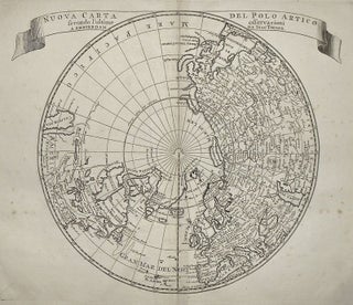
Nuova Carta Del Polo Artico secondo l'ultime observaioni
Amsterdam: Giovanni Battista Albrizzi, 1740. Map. Uncolored copper plate engraving. Image measures 11 x 12.75". Rarely seen in black and white, this map of the North Pole and Northern Hemisphere demonstrates geographic knowledge as of the mid-18th century. The map shows the Northeast Passage, or northern sea route, discovered by William Barentsz in 1596, as well as the islands of Nova Zembla and Spitzbergen that he also discovered. However, the corresponding region in North America, and therefore a possible Northwest..... More