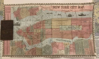
New York City Map; 'What to See and How to See it, Phelps Strangers Guide to New York City with Maps and Engravings'
New York: Gaylord Watson, 1857. Case Map. Vividly hand colored. Image measures 16 x 29 inches. Comes with 6 x 4 inch booklet brown covers with embossed gold lettering 'What to See and How to See it, Phelps Strangers Guide to New York City with Maps and Engravings', 70pp. This elegant street map of New York City covers Manhattan from the Battery north to 132nd street as it existed in 1857. Parts of Brooklyn, Queens, Jersey City and Hoboken are..... More