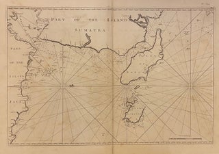
Untitled, Plate XIX (Part of the Island Sumatra)
London: Henry Gregory, 1766. Sea chart. Uncolored engraving. Image measures 19 5/8" x 29 1/4" inches, sheet measures 22 1/2" x 32 1/8"inches. Striking sea chart based on a VOC manuscript map; fathoms, depths rocks and safe soundings are noted. The map depicts the Straits of Sunda, a important sailing route connecting the Pacific and Indian Oceans; part of the island of Sumatra, and part of west Java, including Batavia, or present-day Jakarta; as well as the Island of Banca..... More