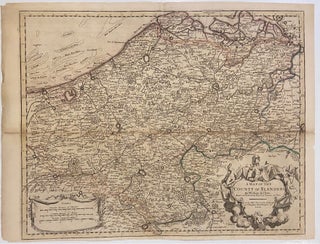
A Map of the County of Flanders
London: John Senex. Map. Engraving with hand coloring. Image measures 24 1/2" x 19 1/4". Beautiful map of Flanders circa 1715, extending from Brussels and Antwerp in the right margin, to Saint-Omer (present-day France) in the west. The map is colored to show regional borders of the time. Shows roads, rivers, and forests; towns and cities are extensively labeled. A decorative cartouche in the lower right corner attributes the map to William de l'Isle, member of the Academy Royal of..... More