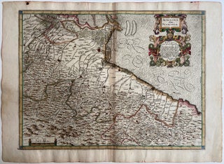
Romagna olim Flaminia
Bologna: Sebastiano Bononi, 1620. Map. Engraving with hand coloring. Image measures 15 1/2" x 21 1/4". Beautifully detailed map of the eastern portion of Emilia-Romagna, extending from Pesaro in the south toward Molinella in the north. State boundaries are hand colored, and mountains, grasslands, and cities are depicted pictorially, with cities colored in red. The map also features lavish ornamental cartouches, and the ocean waves are in Mercator's signature style. Unlike similar maps by Magini, this map features a prominent..... More