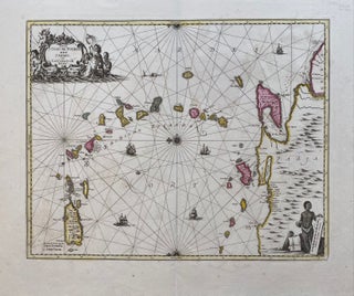
Insula S. Juan De Puerto Rico Caribes uvel Canibasum Insulae
Amsterdam: Schenk, 1700. Map. Copper plate engraving with original hand color. Published 1700. Image measures 19" x 22 1/4". This rare and beautiful sea chart of the West Indies with north oriented to the left, features the Windward Islands. Puerto Rico to Trinidad and the Coast of Venezuela are included with part of Guiana. The elaborate title cartouche, with mermaids and mermen, is finely painted with original coloring. The scale cartouche features an indigenous trader with coils of tobacco and..... More