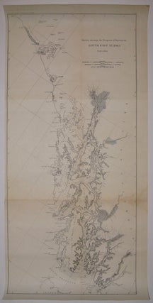
Sketch Showing the Progress of Surveys in South East Alaska
Coast and Geodetic Survey Report, 1896. Map. Uncolored lithograph. Image measures 29.75" x 13 5/8". Beautifully detailed chart of the Alexander Archipelago, from Cape Yakataga to the Dixon Entrance, including Juneau. This survey was made while Alaska was a "district" and around the time gold was discovered in neighboring Yukon Territory. The discovery prompted a large influx of settlers and encouraged further exploration and mapping of the area. Stain to lower right and minor aging along original folds... More