Results
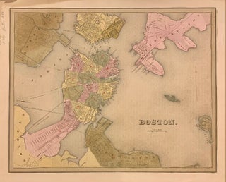
Boston
Boston: T.G. Bradford, 1838. Map. Engraving with original hand coloring. Image measures 11 3/8" x 14 1/8". Beautiful early map of Boston and parts of Cambridge, Brookline, Charlestown, East and South Boston. Showing wards, streets parks, railroads and notable landmarks. Light scattered foxing, stain and minor wear to upper right corner, with stains to margins and some offsetting. Thomas Gamaliel Bradford (1802-1887) was a Boston based publisher. He worked as assistant editor of the American Encyclopedia before entering the field..... More
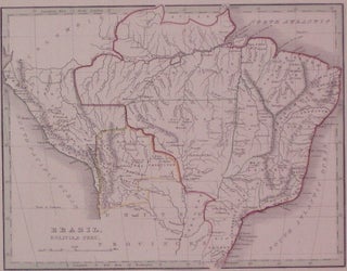
Brazil, Bolivia, & Peru.
Boston: Ticknor, W.D., 1835. Map. Engraving with original color outline. Image measures 7.75" x 10". Brazil in 1835 from Guyana and Colombia in the north to Uruguay in the south and from Bolivia in the west to the Atlantic. T.G. Bradford (1802-1887) was a Boston based publisher. He worked as assistant editor of the American Encyclopedia before entering the field of map making. More
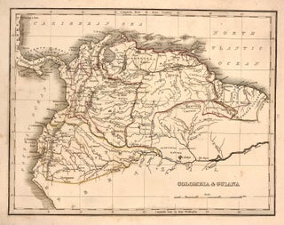
Colombia & Guiana
Boston: W.D. Ticknor, 1835. Map. Engraving with original hand outline. Image measures 7.75" x 10". From "A Comprehensive Atlas Geographical, Historical and Commercial". Minor discoloration in margins. T.G. Bradford (1802-1887) was a Boston based publisher. He worked as assistant editor of the American Encyclopedia before entering the field of map making. More
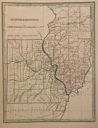
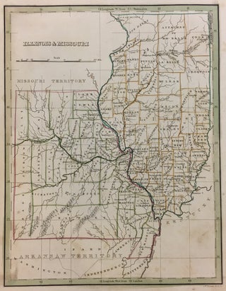
Illinois & Missouri
Boston: Bradford, Thomas Gamaliel, 1835. Map. Engraving with original outline coloring. Image measures 10" x 8". Charming map of Illinois and Missouri Territory, divided into counties showing town, geographical features and Indian tribes. Light scattered foxing. T.G. Bradford (1802-1887) was a Boston based publisher. He worked as assistant editor of the American Encyclopedia before entering the field of map making. More
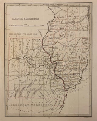
Illinois & Missouri
Boston: Bradford, Thomas Gamaliel, 1835. Map. Engraving with original outline coloring. Image measures 10" x 8". Charming map of Illinois and Missouri, divided into counties. Shows town, geographical features and Indian tribes. Light scattered foxing. T.G. Bradford (1802-1887) was a Boston based publisher. He worked as assistant editor of the American Encyclopedia before entering the field of map making. He was best known for his 1835 "A Comprehensive Atlas: Geographical, Historical & Commercial" and his 1838 "Illustrated Atlas Geographical, Statistical..... More
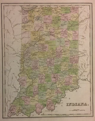
Indiana.
Boston: T.G. Bradford, 1838. Map. Engraving with original hand coloring. Image measures 14 3/8" x 11 1/8". Nice early map of Indiana divided into counties and townships showing major routes, railroads and geographical details. Minor overall wear, pinholes to right edge, small tear to bottom edge. T.G. Bradford (1802-1887) was a Boston based publisher. He worked as assistant editor of the American Encyclopedia before entering the field of map making. He was best known for his 1835 "A Comprehensive Atlas..... More
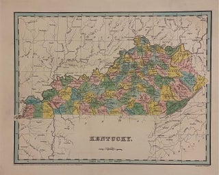
Kentucky
Boston: Bradford, Thomas Gamaliel, 1838. Map. Engraving with hand-colored outline. Image measures 11 3/8" x 14 1/2" Early map of Kentucky divided into counties. Shows towns, waterways, railroads and topographical details. In very good condition. Minor wear to margins, not affecting the image. T.G. Bradford (1802-1887) was a Boston based publisher. He worked as assistant editor of the American Encyclopedia before entering the field of map making. More
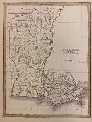
Louisiana and part of Arkansas
Boston: W.D. Ticknor, 1835. Map. Engraving with original hand outline. Image measures 7 3/4" x 10 1/4". Lovely map of Louisiana and Arkansas published in 1835. Hand colored to show early county divisions. Rivers, cities, and parishes are labeled. The Masserne Mountains, now known as the Ozarks, are depicted pictorially. Several Indian villages are noted - including Caddo, Coshatta, and Delaware. From "A Comprehensive Atlas Geographical, Historical and Commercial". Minor foxing to margins. T.G. Bradford (1802-1887) was a Boston based..... More
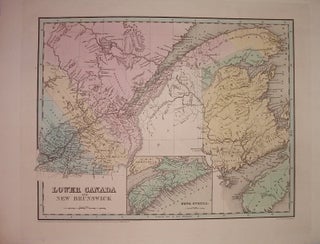
Lower Canada and New Brunswick
Boston: Bradford, Thomas Gamaliel, 1838. Map. Engraving with original hand coloring. Image measures 11.25" x 14.25". Includes inset of Nova Scotia. T.G. Bradford (1802-1887) was a Boston based publisher. He worked as assistant editor of the American Encyclopedia before entering the field of map making. More
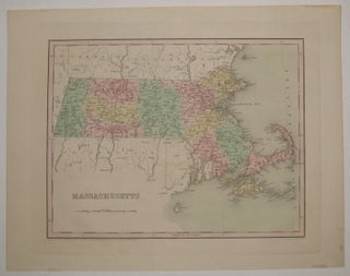
Massachusetts
Boston: T.G. Bradford, 1838. Map. Engraving with original hand coloring. Image measures 11 1/8" x 14 3/8". Nice early map of Massachusetts divided into counties and townships showing major routes, railroads and geographical details. Minor tape residue to top and bottom edges. Full original margins. T.G. Bradford (1802-1887) was a Boston based publisher. He worked as assistant editor of the American Encyclopedia before entering the field of map making. More
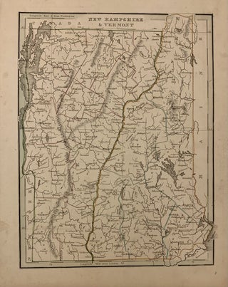
New Hampshire & Vermont
Boston: Bradford, Thomas Gamaliel, 1835. Map. Engraving with original hand outline coloring. Image measures 10" x 7.75". Nice map of New Hampshire and Vermont divided into counties. Details towns and waterways. Minor scattered foxing, mainly to margins. Small chip to left edge. T.G. Bradford (1802-1887) was a Boston based publisher. He worked as assistant editor of the American Encyclopedia before entering the field of map making. More

New York
Boston: T.G. Bradford, 1835. Map. Engraving with original hand coloring. Image measures 7 3/4" x 10 1/8" Beautiful map of New York State divided by county, from the first edition of Bradford's "A Comprehensive Atlas". Cities, towns, major routes, rivers, railroads, and canals are labeled. In very good condition, with very faint scattered foxing and minor wear to margins not affecting the image. Thomas Gamaliel Bradford (1802-1887) was a Boston based publisher. He worked as assistant editor of the American..... More
New York
Boston: T.G. Bradford, 1838. Map. Engraving with original hand coloring. Image measures 14" x 11 1/4" Beautiful map of New York State, colored to show counties. Cities, towns, major routes, rivers, railroads, and canals are labeled. A dark and clear impression with delicate hand coloring. In very good condition, with minor wear to margins not affecting the image. Thomas Gamaliel Bradford (1802-1887) was a Boston based publisher. He worked as assistant editor of the American Encyclopedia before entering the field..... More
North America.
Boston: Bradford, Thomas Gamaliel, 1838. Map. Engraving with full original color. Image measures 14.25 x 11.25 inches. Sheet measures 19.5 x 15.25 inches. Beautiful map of North America that predates the Mexican American War and the annexation of Texas, Upper California and Texas are not yet part of the States. Shows the United States' claim of British Columbia as far north as 54 40.' In very good condition. Shows some light foxing, some staining to margins. T.G. Bradford (1802-1887) was..... More
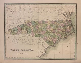
North Carolina
Boston: Bradford, Thomas Gamaliel, 1839. Map. Engraving with original hand coloring. Image measures 11 3/8" x 14 1/2" Beautiful early map of North Carolina divided into counties, showing towns, major routes, railroads and geographical details. The map is in good condition. Small closed tears at margins. T.G. Bradford (1802-1887) was a Boston based publisher. He worked as assistant editor of the American Encyclopedia before entering the field of map making. He was best known for his "important contributions to American..... More
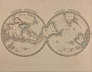
Northern Hemisphere / Southern Hemisphere
Boston: Bradford, Thomas Gamaliel, 1835. Map. Engraving with original hand outline coloring. Image measures 10" x 7.75". Unusual polar projection world map with wonderful joined design. Australia is still called New Holland. T.G. Bradford (1802-1887) was a Boston based publisher. He worked as assistant editor of the American Encyclopedia before entering the field of map making. More
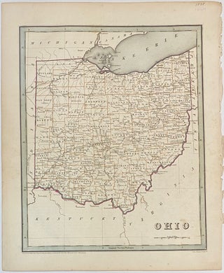
Ohio
Boston: T.G. Bradford, 1838. Map. Engraving with original hand colored outline. Image measures 14" x 11 1/4". Nice early map of Ohio divided into counties and townships showing major routes, railroads and geographical details. This is the first edition of this map. published in 1838. Minor overall wear, pinholes to right edge, faint scattered foxing. T.G. Bradford (1802-1887) was a Boston based publisher. He worked as assistant editor of the American Encyclopedia before entering the field of map making. He..... More
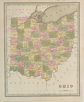
Ohio
Boston: T.G. Bradford, 1838. Map. Engraving with original hand coloring. Image measures 14" x 11 1/4". Nice early map of Ohio divided into counties and townships showing major routes, railroads and geographical details. This is the first edition of this map. published in 1838. In very good condition. Minimal foxing to margin, not affecting the image. T.G. Bradford (1802-1887) was a Boston based publisher. He worked as assistant editor of the American Encyclopedia before entering the field of map making..... More
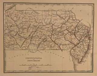
Pennsylvania and New Jersey
Boston: Bradford, Thomas Gamaliel, 1835. Map. Engraving with original hand outline coloring. Image measures 8" x 10". Great map of Pennsylvania and New Jersey divided into counties. Delineates towns, topography and waterways. Minor wear to edges. T.G. Bradford (1802-1887) was a Boston based publisher. He worked as assistant editor of the American Encyclopedia before entering the field of map making. He was best known for his 1835 "A Comprehensive Atlas: Geographical, Historical & Commercial" and his 1838 "Illustrated Atlas Geographical..... More
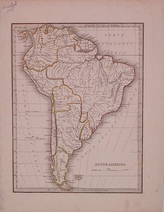
South America
Boston: Bradford, Thomas Gamaliel, 1835. Map. Engraving with original hand outline coloring. Image measures 10" x 7.75". Some foxing. T.G. Bradford (1802-1887) was a Boston based publisher. He worked as assistant editor of the American Encyclopedia before entering the field of map making. More
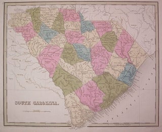
South Carolina.
Boston: Bradford, Thomas Gamaliel, 1838. Map. Engraving with original hand outline coloring. Image measures 11.5" x 14.25". Beautiful map of South Carolina divided into counties. Shows towns and waterways. In very good conditon with light foxing to outer margins and faint creasing. T.G. Bradford (1802-1887) was a Boston based publisher. He worked as assistant editor of the American Encyclopedia before entering the field of map making. More
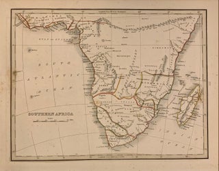
Southern Africa
Boston: W.D. Ticknor, 1835. Map. Engraving with original outline coloring. Image measures 7.5" x 10". Early map of South Africa with elevations shown pictorially. Tribal notations included along with major towns. Extends as far north as the fictional 'Mountains of Kong and Mountains of the moon. Thomas Gamaliel Bradford (1802-1887) was a Boston based publisher. He worked as assistant editor of the American Encyclopedia before entering the field of map making. He was best known for his important contributions to..... More
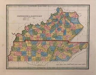
Tennessee & Kentucky
Boston: Bradford, Thomas Gamaliel, 1835. Map. Engraving with hand-coloring. Image measures 7 7/8" x 10 1/8" Early map of Tennessee and Kentucky divided into counties. Shows towns, waterways, railroads and topographical details. Published after the passage of the Indian Removal Act 1830, but before Cherokee Removal in 1838, this map includes Cherokee Territory (and Brainerd mission) in the southeast corner. Minor spotting at margins, not affecting the image. T.G. Bradford (1802-1887) was a Boston based publisher. He worked as assistant..... More