
Terra Cotta of the Italian Renaissance.
New York: National Terra Cotta Society, 1925. 200 photographic plates. 4to, black cloth-backed brown boards, corners bumped. New York: National Terra Cotta Society, (1925). Very good. More
New York: National Terra Cotta Society, 1925. 200 photographic plates. 4to, black cloth-backed brown boards, corners bumped. New York: National Terra Cotta Society, (1925). Very good. More
Stamford: Overbrook Press, 1939. Black and white illustrations and facsimiles, some folding. 62pp. Short slim 4to, red cloth (spine evenly faded); uncut edges, broken board slipcase. Stamford, CT: Overbrook Press, 1939. A very good copy in a poor slipcase. Limited Edition, one of 650 copies. More

New York: Harper, 1940. Frontispiece, black and white plates, 362 pages, thick 8vo, red cloth (spine a bit toned). New York and London: Harper, 1940. First Edition. A near fine copy. Signed in full and inscribed on the front free endpaper: "When I write inside every other copy of this book that I write inside, I say "For" so-and-so. In this one and only copy I can say To Letitia Cunningham Rogers February 7, 1940." More
London: Hamish Hamilton, 1952. 308pp. 8vo, orange cloth, edges of corners lightly worn and bumped, otherwise very good. London: Hamish Hamilton, (1952). More
New York: Harper, 1931. Illus. 8vo, red cloth, head of spine worn, edges of corners worn and bumped, cloth lightly soiled. New York: Harper, 1931. More
Boston: Colonial Society of Massachusetts, 1954. Volumes 36 and 37 only. Illustrated in black and white. xvi, 1315 pages. Very thick 8vos, gilt-stamped blue cloth (spines faded). Boston: Colonial Society of Massachusetts, 1954. Page edges lightly stained, internally clean and tight. Very good(+). More
many illus. 4to, cloth, d.w. (Tulsa: Continental Heritage, 1981). vg. More
London: Kegan Paul, 1947. 388 pages of text. Illustrated at rear with 160 black and white plates. Short 4to, blue cloth (spine sunned; some small dents on cover). London: Kegan Paul, (1947). A very good solid copy. More
New York: Abrams, 1968. Illustrated with 277 plates, including 148 in color; 5 maps. 264 pages. Square 8vo, cloth, d.w. New York: Abrams, (1968). A fine copy in a very good(+) dust wrapper. Panorama of World Art series. More
New York: 1975. New York, (1975). More
Chicago: University Press, 1962. ix, 311 pages. 8vo, blue cloth. Chicago: Chicago University Press, (1962). A bit scuffed but internally clean. A very good (+) copy. More
New York: Harper & Brothers Publishers, 1945. Some black and white illustrations, European map on endpapers. 321 pages. 8vo, black cloth with gilt lettering. New York: Harper and Brothers Publishers, (1945). Toned text block. A very good(+) copy. Series edited by William L. Langer. More
New York: Van Nostrand, 1912. Assisted by Clarence A. Pierce. Many text illustrations, diagrams, and formula. xiii + 360 pages, 8vo, green cloth; rubbed; ownership names inside front cover and facing endpaper. New York: D. Van Nostrand Company, 1912. Second edition. A very good copy. More
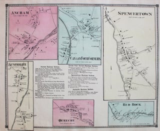
New York: Beers, Comstock, & Cline, 1873. Map. Lithograph with original hand coloring. Sheet measures 13 3/4" x 16 1/2" This 1873 map by Frederick W. Beers shows the Ancram, Austerlitz, Canaan Four Corners, Spencertown, Red Rock, Queech Frederick W. Beers (flourished 1858-1929) came from a family of surveyors, cartographers and publishers originally from Newtown Connecticut. F.W. Beers continued the work of his father James Botsford Beers and was known for his county survey maps of New York, Ohio, Pennsylvania..... More
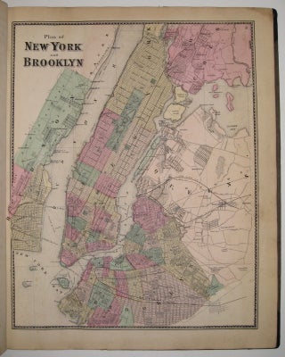
New York: F.W. Beers, A.D. Ellis & G.G. Soule, 1867. Atlas with 61 lithographed maps (11 of which fold out) and 5 views. Folio, measures 18" x 15". Original brown cloth binding with gold stamped title. Black leather spine and corners have been rebacked with black book cloth. Repair to title page, a few minor tears, scattered foxing throughout. Title page embossed at lower right by Landmarks Book Shop, Poughkeepsie; New York and Vicinity map has tear to left. Maps..... More
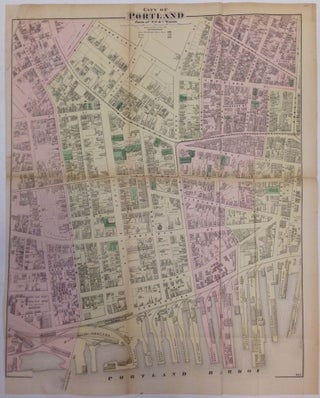
New York: Beers, F.W. & Co., 1871. Map. Engraving with original hand coloring. Sheet measures 33.25" x 26.5". Wonderful map of Portland, Maine from 1871, showing the Old Port district from Portland Harbor to Cumberland Street. Shows wharfs, waterways, bridges, railroads, streets, landowners and businesses. Light offsetting. Repair at top left margin. Frederick W. Beers (flourished 1858-1929) came from a family of surveyors, cartographers and publishers originally from Newtown Connecticut. F.W. Beers continued the work of his father James Botsford..... More
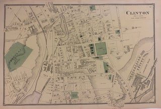
New York: Beers, Comstock, & Cline, 1870. Map. Engraving with original hand coloring. Image measures 14 1/4" x 22 1/2" This 1870 map by Frederick W. Beers shows the town of Clinton, Massachusetts. This map was published in Beers' Atlas of Worcester County, Massachusetts (1870). Frederick W. Beers (flourished 1858-1929) came from a family of surveyors, cartographers and publishers originally from Newtown, Connecticut. F.W. Beers continued the work of his father James Botsford Beers and was known for his county..... More
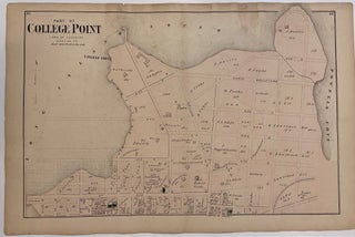
1871. Map. Engraving with original hand coloring. 15 1/2 x 23 1/2 inches. Detailed map of College Point in Queens County, New York. Both the Long Island Sound and Powells Cove are visible. Frederick W. Beers (flourished 1858-1929) came from a family of surveyors, cartographers and publishers originally from Newtown Connecticut. F.W. Beers continued the work of his father James Botsford Beers and was known for his county survey maps of New York, Ohio, Pennsylvania, Michigan, Connecticut and Vermont. Nice..... More
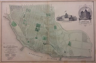
New York: Beers, Comstock, & Cline, 1873. Map. Lithograph with original hand coloring. Sheet measures 15 1/2" x 24". This 1873 map by Frederick W. Beers shows Sea Cliff Grove in the Glen Cove in Suffolk County. The map beautifully renders topographic features, such as swamps, harbors, and lakes, and notes streets, wards, settlements, wards, major buildings, landowners, bridges, wharves, railroads, cemeteries, etc. Shows from Main Avenue down to Hempstead Harbor. Also includes two small insets, one of a famous..... More
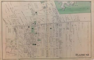
New York: Beers, Comstock, & Cline, 1873. Map. Lithograph with original hand coloring. Sheet measures 24" x 15.5". Shows some small tears at edges, image unaffected. In very good condition. This 1873 map by Frederick W. Beers shows the Flatbush neighborhood of Brooklyn. Verso shows details of Bayridge, New Utrecht and Bath. Included in Beers' Atlas of Long Island, New York (New York: Beers, Comstock, & Cline, 1873). Frederick W. Beers (flourished 1858-1929) came from a family of surveyors, cartographers..... More
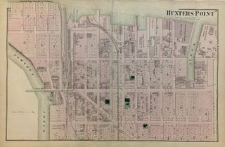
New York: Beers, Comstock, & Cline, 1873. Map. Lithograph with original hand coloring. Sheet measures 15.5" x 24". Shows some foxing. Shows some small tears at edges, image unaffected. In very good condition. This 1873 map by Frederick W. Beers shows Hunters Point, Queens, from Newtown Creek to Division Street, and from the East River to East Avenue (present-day 21st Street). Verso shows details of Winfield, Middle Village, and part of Astoria. Included in Beers' Atlas of Long Island, New..... More
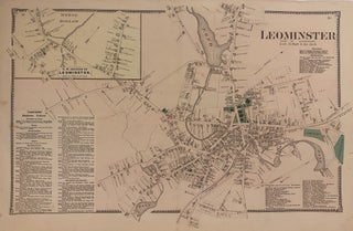
New York: Beers, Comstock, & Cline, 1870. Map. Engraving with original hand coloring. Image measures 14 1/4" x 22 1/2" This 1870 map by Frederick W. Beers shows the town of Leominster, Massachusetts. Includes a business directory, and an inset of the N.W. Section of Leominster (Morse Hollow). This map was published in Beers' Atlas of Worcester County, Massachusetts (1870). Frederick W. Beers (flourished 1858-1929) came from a family of surveyors, cartographers and publishers originally from Newtown, Connecticut. F.W. Beers..... More
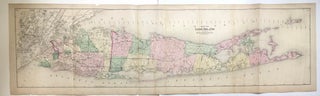
New York: Beers, Comstock, & Cline, 1873. Map. Lithograph with original hand coloring. Sheet measures 15.5" x 54". Shows some foxing. Shows some tears and chips at edges, image unaffected. This 1873 map by Frederick W. Beers shows all of Long Island. Includes part of New Jersey, Westchester and Fisher's Island. Fish oil factories are noted as well as early RR lines. Included in Beers' Atlas of Long Island, New York (New York: Beers, Comstock, & Cline, 1873). Frederick W...... More
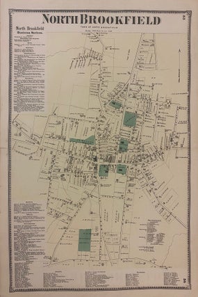
New York: Beers, Comstock, & Cline, 1870. Map. Engraving with original hand coloring. Image measures 21 3/4" x 14 1/4" This 1870 map by Frederick W. Beers shows the town of North Brookfield, Massachusetts. Included in Beers' Atlas of Worcester County, Massachusetts (1870). Frederick W. Beers (flourished 1858-1929) came from a family of surveyors, cartographers and publishers originally from Newtown, Connecticut. F.W. Beers continued the work of his father James Botsford Beers and was known for his county survey maps..... More
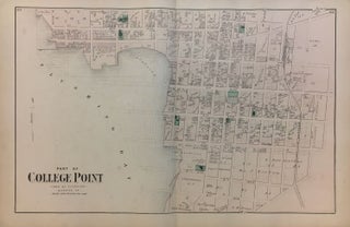
New York: Beers, Comstock, & Cline, 1873. Map. Lithograph with original hand coloring. Sheet measures 15.5" x 24". Shows some small tears at edges, image unaffected. In very good condition. This 1873 map by Frederick W. Beers shows College Point, Flushing, Queens, from River Street and Flushing Bay to 21st Street, and from 2nd Avenue to 9th Avenue. Verso is blank with manuscript notes in pencil. Included in Beers' Atlas of Long Island, New York (New York: Beers, Comstock, &..... More
My book arrived in record time (it shocked me when it arrived so soon after ordering) and was beautifully packaged. If it didn't go via DHL it would never have made it through the Australia Post system unscathed!!! Thank you!
Just wanted to let you know that this wonderful book has arrived and I am so pleased to own. Thank you for the information and prompt service.