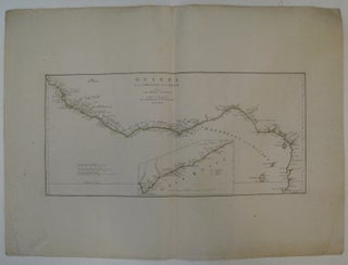
Guinea Zwischen Sierra-Leona und dem Aequator
Vienna: P.J. Schalbacher. Map. Engraving with original hand outline color. Image measures 12" x 26 1/8". This beautifully detailed map follows the western coast of Africa from Guinea to Gabon, circa 1800. Has an inset of hte Gold Coast and indicates Dutch, English and Danish colonial claims. While the plate was originally made by D'Anville, this copy is from Schraembl's "Allgemeiner Grosser Atlas", a work that was published in pieces from 1786 to 1800. D'Anville (1697-1782) was a prolific French..... More