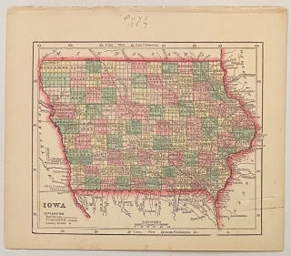
Iowa
New York: Samuel Gaston, 1857. Map. Engraving with original hand coloring. Image measures 5" x 6.25". Charming miniature map of Iowa divided into counties and townships. Shows waterways, railroads, and major cities. The map appeared in Colby's "Diamond Atlas" and is in very good condition. Paperclip indentation in right margin. Minor foxing to lower margin, not affecting the image. Charles G. Colby (1830--1866) was an American map-maker active in the mid-19th century who is known best for his miniature maps..... More