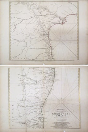
Bowles's New Pocket Map of the Cormandel Coast
London: Bowles, 1794. Map, in two sheets. Colored outline. Top sheet measures 20 3/4" x 28 3/8", bottom sheet measures 20 3/4" x 27 9/16" Beautiful set of maps featuring the Coromandel Coast of southeast India from Narsapur south to Nagapattinam. Important cities, rivers, mountains and lakes noted. The Bowles family of publishers and map sellers were active in London for four generations, from the late 17th century to the early 19th century. Carrington Bowles took over the Cornhill bookshop..... More