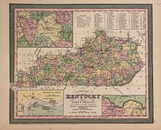
A New Map of Kentucky with its Roads & Distances
Philadelphia: Thomas, Cowpertwaith & Co., 1854. Map. Engraving with original hand coloring. Image measures 11 3/4" x 14" Nice clean map of Kentucky divided into counties. Shows major cities, major routes, waterways and railroads. Includes table of steam boat routes. Includes insets showing larger scale depictions of roads surrounding Lexington, and along the Ohio River near Clarksburg, and at the Falls of Ohio near Louisville. A table in the upper right corner indicates steam boat routes from Louisville to Pittsburgh..... More