
Autos Across America; A Bibliography of Transcontinental Automobile Travel: 1903-1940
Los Angeles: Dawson's Book Shop, 1972. Facsimiles. 60pp. 8vo, green cloth. Los Angeles: Dawson's Book Shop, 1972. A near fine copy. One of 315 copies. More
Los Angeles: Dawson's Book Shop, 1972. Facsimiles. 60pp. 8vo, green cloth. Los Angeles: Dawson's Book Shop, 1972. A near fine copy. One of 315 copies. More
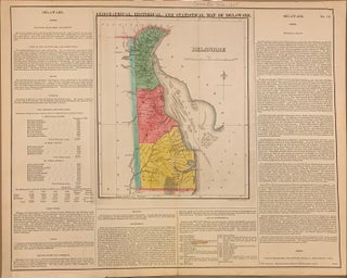
Philadelphia: Carey & Lea, 1822. Map. Engraving with original hand coloring. Map measures 11.75" x 9.75", map plus text measures 16.75" x 21". Fine antique map of Delaware divided into counties, showing towns, major routes and waterways. Includes information pertaining to history, climate and demographics. From "A Complete Historical, Chronological, and Geographical American Atlas..." of 1822. Condition is very good, stain in Governors list. The Philadelphia-based firm of Carey & Lea of Philadelphia was one of the most important publishers..... More
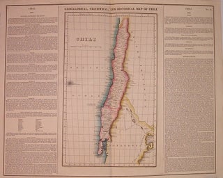
Philadelphia: Carey & Lea, 1823. Map. Engraving with original hand coloring. Image measures 15" x 9", image plus text measure 16.75" x 20.5". Beautiful map of Chili from 1823. Includes information pertaining to history, climate and culture. From "A Complete Historical, Chronological, and Geographical American Atlas..." of 1822. Run by Henry Carey (1793-1879) and Isaac Lea (1792-1886), the company worked with both books and maps, specializing particularly in political commentary. Their "Complete Historical, Chronological, and Geographical American Atlas," first published..... More
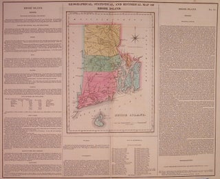
Philadelphia: Carey & Lea, 1822. Map. Engraving with original hand coloring. Image measures 16.5" x 20.25". Page measures 17.5" x 21.75". Great double page map of Rhode Island divided into counties. Shows towns, major routes and waterways. Includes information pertaining to history, climate and culture. Light scattered foxing to margins, and slight toning along centerfold. From "A Complete Historical, Chronological, and Geographical American Atlas..." of 1822. The Philadelphia-based firm of Carey & Lea of Philadelphia was one of the most..... More
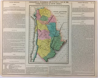
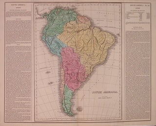
Philadelphia: Carey & Lea, 1822. Map. Engraving with original hand coloring. Image measures 13" x 9", image plus text measures 17" x 21". Includes information pertaining to history, climate and culture. One of the new maps of Argentina after it declared its independence from Spain in 1816. From "A Complete Historical, Chronological, and Geographical American Atlas..." of 1822. Top margin cropped. The Philadelphia-based firm of Carey & Lea of Philadelphia was one of the most important publishers in the early..... More
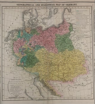
Philadelphia: Carey & Lea, 1823. Map. Engraving with original hand coloring. Map measures 9 3/4" x 11 3/4". Map plus text measures 17 3/4" x 22 3/8". Detailed and informative map of Germany divided according to the Treaty of Paris showing major routes. Austria and Prussia are included. Surrounding text includes geographical information, as well as information on population, commerce, education, religion, and government. Flags note the history ow battles. From Some toning an chips to margins but otherwise in..... More
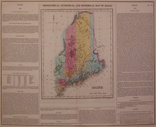
Philadelphia: Carey & Lea, 1822. Map. Engraving with original hand coloring. Map measures 11.75" x 9.5", map plus text measures 16.5" x 20.5". Nice map of Maine divided into counties. Shows towns, major routes and waterways. Includes information pertaining to history, climate and demographics. The map was printed in Carey & Lea's 1822 "Complete Historical, Chronological, and Geographical American Atlas." Small tear to bottom center and a few chips to edges. The Philadelphia-based firm of Carey & Lea of Philadelphia..... More
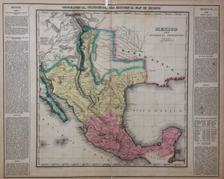
Philadelphia: Carey & Lea, 1822. Map. Engraving with original hand coloring. Image measures 15"x 14.5", image plus text measures 16.5" x 20.5". This map of Mexico combines a detailed topographical and political rendering with information pertaining to history, climate and culture. It was published in 1822, shortly before Austin's arrival in Texas and immediately prior to Mexico's independence from Spain. The index of the map includes cities, rivers, military posts, and mines, and information about exploration and Indian population is..... More
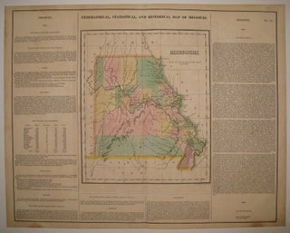
Philadelphia: Carey & Lea, 1822. Map. Engraving with original hand coloring. Image measures 11 7/8" x 10", image plus text measures 16.5" x 20 5/8". Great double page map of Missouri divided into counties. Shows towns, major routes, waterways and topography. Extensive information pertaining to history, climate and culture surrounds map. From "A Complete Historical, Chronological, and Geographical American Atlas...". Light scattered staining and foxing, mainly to margins. The Philadelphia-based firm of Carey & Lea of Philadelphia was one of..... More
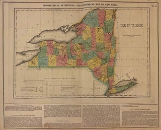
Philadelphia: Carey & Lea, 1823. Map. Engraving with original hand coloring. Map measures 11.75" x 18.25", map plus text measures 16.5" x 19.5". Beautiful double page map of New York state divided into counties. Shows towns, waterways, major routes, and geographical features. A table illustrates the profile levels of the Grand Canal. Includes information pertaining to climate and geography. From "A Complete Historical, Chronological, and Geographical American Atlas..." of 1822. Very small tears to edges. In very good condition... More
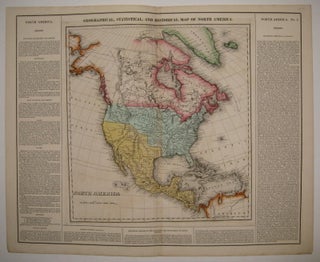
Philadelphia: Carey & Lea, 1823. Map. Engraving with original hand coloring. Image measures 14" x 13.25", image plus text measures 16.5" x 20.5". Beautiful double page map of North America. Towns, states, waterways and topographical details shown in immense detail. Extensive information pertaining to history, climate and culture surrounds map. From "A Complete Historical, Chronological, and Geographical American Atlas...". Minor toning along original centerfold. More
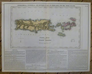
Philadelphia: Carey & Lea, 1822. Map. Engraving with original hand coloring. Image measures 15"x 14.5", image plus text measures 16.5" x 20.5". Beautiful map of Puerto Rico and the Virgin Islands on a large scale. An explanation of colonial activity is provided as well as the publisher's signature text surround pertaining to history, climate and culture. The map was printed in Carey & Lea's "Complete Historical, Chronological, and Geographical American Atlas". Very good condition with no chips or tears or..... More
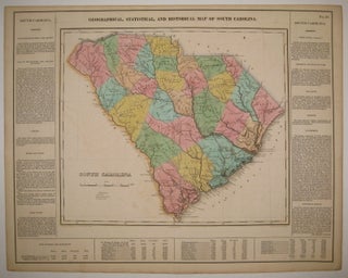
Philadelphia: Carey & Lea, 1822. Map. Engraving with original hand coloring. Image measures 12.75" x 14.75", image plus text measures 16.25" x 20.75". Beautiful double page map of South Carolina divided into counties. Towns, states, waterways and topographical details shown in immense detail. Extensive information pertaining to history, climate and culture surrounds map. From "A Complete Historical, Chronological, and Geographical American Atlas...". Very light offsetting, small tear to right edge. Center fold re-inforced. Small stain to upper right. Otherwise in..... More
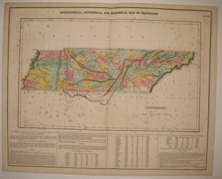
Philadelphia: Carey & Lea, 1822. Map. Engraving with original hand coloring. Image measures 11 7/8" x 10", image plus text measures 16.5" x 20 5/8". Rare double page map of Tennessee divided into counties. Shows towns, major routes, waterways and topography. Extensive information pertaining to history, climate and culture surrounds map. From "A Complete Historical, Chronological, and Geographical American Atlas...". Foxing throughout entire sheet, as is common with this map due to its placement in the atlas. Priced as is..... More
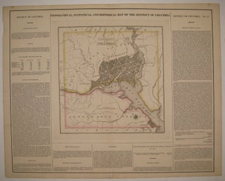
Philadelphia: Carey & Lea, 1822. Map. Engraving with original hand coloring. Image measures 10.75" x 10.5", image plus text measures 16.5" x 20 5/8". Beautiful double page map of Washington D.C. and its environs, including Alexandria. Shows street plan, major roads, waterways, marshlands and topography. Extensive information pertaining to history, climate and culture surrounds map. From "A Complete Historical, Chronological, and Geographical American Atlas...". Crease to upper right, light spots of foxing to top margin. Expert repair to centerfold... More
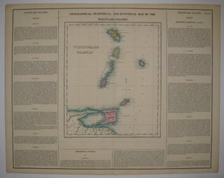
Philadelphia: Carey & Lea, 1822. Map. Engraving with original hand coloring. Image measures 11 5/8" x 10", image plus text measures 16 5/8" x 20.75". Nice map of the Windward Islands, including information pertaining to history, climate and culture of Martinique, St. Lucia, St. Vincent, Barbados, Grenada, Trinidad and Tobago. From "A Complete Historical, Chronological, and Geographical American Atlas..." of 1822. Minor aging along edges, small chip to lower right corner. More
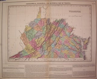
Philadelphia: Carey & Lea, 1823. Map. Engraving with original hand coloring. Map measures 12" x 18". Map plus text measures 16.5" x 20.5". Early map of Virginia divided into counties. Shows towns, waterways, major routes and topographical features. Surrounding text includes geographical information and a separate appendix has information on demographics, chief towns, internal improvements, canals, literary fund, education, agriculture and commerce, government and religion. Appendix included. From "A Complete Historical, Chronological, and Geographical American Atlas..." of 1822. Minor toning..... More
Philadelphia: Carey & Lea, 1822. Map. Engraving with original hand coloring. Image measures 16.5" x 12", image plus text measures 16.5" x 20.25". Includes information pertaining to history, climate and culture. From "A Complete Historical, Chronological, and Geographical American Atlas..." of 1822. Minor foxing along upper margins. More
London: Wertheim, 1858. Translated from the Hebrew. Illustrated with 80 woodcuts and a folding map, some scattered foxing, including the title page and map. 486 pages. Tall 8vo, 3/4 brown morocco, marbled boards. London: Wertheim, Macintosh, and Hunt, 1863. Very good. More
Salem: Oregon Historical Society, 1926. 543 pages with text in double columns. Tall thick 8vo, gilt-lettered burgundy cloth. Salem: Oregon Historical Society, 1926. Spine lettering dull, and lacking the front endpaper, else a very good solid copy. More
Hampshire, England: The Delphic Press, 1949. Slim 8vo, wrappers housed in black cloth binders. Hampshire, England: The Delphic Press, (1949, 1950, 1951, 1952, 1955). Very good. More
New York: Knopf, 1988. Illustrated. 331pp, 8vo, cloth-backed boards, dust wrapper. N.Y.: Alfred A Knopf, 1988. A near fine copy in a very good dust wrapper. More
New York: Dutton, 1977. Illustrated. 248pp. 8vo, cloth-backed boards. New York: E. P. Dutton, 1977. Near-fine copy in a very good dust wrapper. More
1983. 284pp. 8vo, bds., d.w. N.Y.: St. Martin's Press, 1983. vg. More
Indianapolis: Liberty Fund, 1995. 8vo, pr. wrs. Indianapolis: Liberty Fund, 1995. Indianapolis: Liberty Fund, 1995. Fine. More
I received my book by Frans Masereel in the mail this afternoon. I couldn't be more delighted. It's in excellent condition, and your shipping and customer service were first rate. This was my first experience purchasing a rare book online -- thanks for making it a good one.
Dear Sirs, Just to let you know, I've received my order -- it's a beautiful copy -- thank you again for your attention.