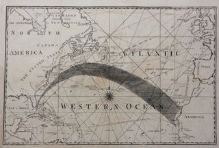
Gulf Stream Map - Atlantic or Western Ocean
Philadelphia: American Philosophical Society. Map. Engraving. Uncolored. Image measures 12" x 20". Page measures 21.25" x 17.5". This late-18th-century map illustrates the phenomenon of the Gulf Stream as named and first charted by Benjamin Franklin in 1762. A thick band of engraved lines visualize the ocean current flowing from the Gulf of Mexico up the Eastern seaboard and then east to the coast of Africa, labelled as "Azanhaga." Jones' map builds on Franklin's initial example by providing contextual information that..... More
