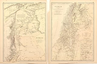
Syria (North Division) and Syria (South Division) including Palestine & the Hauran
Edinburgh & London: Blackie & Son, 1883. Maps, set of 2. Color lithographs. Each sheet measures 14 3/4" x 11" Incredibly detailed map of Syria, Lebanon, and Palestine, extending from Rafah to the Taurus Mountains. Major cities, rivers and hydrological features, important structures, and topographical details are labeled. Roads are carefully delineated, showing major routes, Roman roads, and the Hajj. An inset in the lower right corner of the southern sheet depicts the Environs of Jerusalem. In very good condition..... More