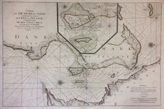
Carte du De Troit du Sond Contenant les Costes de l'Isle de Zelande Comprises entre Nicopen et l'Isle de Meun., et Celles du Schonen depuis la Poiinte de Kol, jusqu'a Valsterbon.
Amsterdam: Pierre Mortier, 1693. Sea chart. Engraving with original hand outline color. Image measures 22.75" x 34.75". Stunning sea chart of the eastern coast of Sjaelland (Zealand) in Denmark and the western coast of Sweden. Includes Copenhagen, Amager and Helsingoer (Elsinore). A large inset shows Copenhagen. Rhumb lines throughout and three compass roses. Beautifully detailed geographic features include topography, farm land and sand bars. Published in "Le Neptune Francois" in Amsterdam. Wear along original fold, horizontal fold, minor creasing to..... More