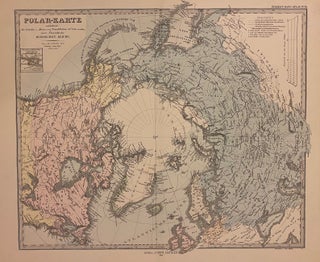
Polar-Karte
Gotha: Justus Perthes, 1877. Map. Steel engraving with original hand coloring. Image measures 13 1/2" x 15 1/2" This striking 1877 map was published by Justus Perthes for Stieler's Hand Atlas. Centered on the North Pole, the map depicts northern Europe, Russia, Canada, Alaska and Greenland. Coastlines and island groups are extensively labeled, as are important cities, lakes, rivers, mountains, and other topography. Text in German. This map appeared in the 1877 issue of Stieler's Hand Atlas. In excellent condition..... More