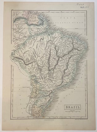
Brazil
Edinburgh: A. & C. Black, 1851. Map. Color lithograph. Image measures 15" x 10 1/4" This lovely map of the Brazil was published in 1851 in Black's General Atlas of the World. The map is labeled in great detail, showing rivers, towns, mountains, and coastal features. Delicately colored to show national boundaries, including neighboring Uruguay, Paraguay, and British Guayana, Dutch Guyana, and French Guyana. The map is in excellent condition. Adam Black (1784-1874) was a Scottish publisher and politician who..... More