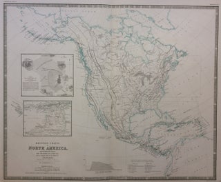
Mountain Chains in North America; with Humboldt's Plan of The Volcano of Jorullo and an enlarged map of the Island of Trinidad.
Edinburgh and London: William Blackwood and Sons, 1849. Map. Engraving. Image measures 18.5 x 22.75 inches. Sheet measures 21.5 x 25.75 inches. In very good condition. Shows some light damp-staining. Engraved by W. and A.K. Johnston. This fascinating and informative map describes the orography--the formation and relief of mountains--of North America based on recent scientific surveys. In the body of the map, black lines indicate mountain chains, and dashed lines indicate undetermined mountainous regions. Minute hachures delicately describe the slope..... More