
Mr. Dooley Remembers; The Informal Memoirs of Finley Peter Dunne
Boston: Little Brown, 1963. Ed. by Philip Dunne. 8vo, green cloth, d.w., ex libris, front flyleaf lacking. Boston: Little Brown, (1963). More
Boston: Little Brown, 1963. Ed. by Philip Dunne. 8vo, green cloth, d.w., ex libris, front flyleaf lacking. Boston: Little Brown, (1963). More
Stanford: Academic Reprints, 1954. Ed. by Louis Filler. Illus. Small 8vo, red cloth, d.w. chipped and torn, head of cloth spine worn. Stanford: Academic Reprints, 1954. More
New York: Russell, 1901. 8vo, gilt decorated green cloth. New York: R.H. Russell, 1901. First Edition. More
Boston: Small Maynard, 1898. 8vo, green cloth Boston: Small Maynard, 1898. First Edition. The author's first book. Near fine copy, with the date December 25, 1898 written on the flyleaf. More
New York: R. H. Russell, 1900. Illus. 12mo, original red cloth, head of spine lightly worn, corners bumped, cloth lightly soiled, spine sunned. New York: R. H. Russell, (1900). More
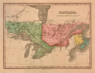
Philadelphia: Anthony Finley, 1824. Map. Engraving with original hand coloring. Image measures 9" x 11 1/2" Beautiful early map of Canada, then known as Upper Canad and Lower Canada, Extending to Winnipeg River. Toronto is still named York, Roads, waterways, islands, geographical features are labeled. Great lakes are all labelled. Extensive notes on Indigenous regions are noted. In very good condition, with extra care taken with the original coloring. Anthony Finley (c. 1790-1840) was a prominent American cartographic publisher in..... More
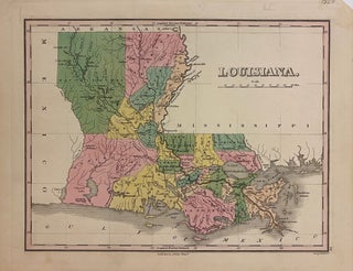
Philadelphia: Finley, Anthony, 1824. Map. Engraving with original hand coloring. Image measures 8 5/8" x 11 3/8". Classic map of Louisiana showing early county divisions. Includes historic counties of Natchitoches, Opelousas, and Attakapas. Shows major towns, routes and waterways. Several Indian villages are noted, including Caddo and Coshatta. Minor toning to edges. Anthony Finley (c. 1790-1840) was a prominent American cartographic publisher in the early 19th century. This map was published in "A New General Atlas", which was well received..... More
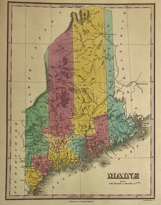
Philadelphia: Finley, Anthony, 1829. Map. Engraving with original hand coloring. Image measures 11.5" x 8.5". Nice map of Maine divided into counties, showing towns, major routes and waterways. Minor wear to margins. Right corners chipped. Originally published in 1824, this is the fifth state of this map printed in 1829, and the only one to depict Waldo County, which was incorporated in 1827. (Thompson 54) Anthony Finley (c. 1790-1840) was a prominent American cartographic publisher in the early 19th century..... More
Philadelphia: Finley, Anthony, 1824. Map. Engraving with original hand coloring. Image measures 8.75 x 11.25 inches. Sheet measures 10.25 x 13.5 inches. In very good condition. Some small chips at edges and very minor staining to margins, image is uneffected. A nice map of Maryland divided into counties. Shows towns, major routes and waterways. In excellent condition. Anthony Finley (c. 1790-1840) was a prominent American cartographic publisher in the early 19th century. This map was published in "A New General..... More
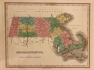
Philadelphia: Anthony Finley, 1827. Map. Engraving with original hand coloring. Image measures 9" x 11 1/2" Classic map of Massachusetts divided into counties. Cities, towns, roads, waterways, islands, geographical features are labeled. In very good condition, with some foxing in the coastal area off of Cape Cod. Otherwise clean and bright with extra care taken with the original coloring. Anthony Finley (c. 1790-1840) was a prominent American cartographic publisher in the early 19th century. He is best known for his..... More
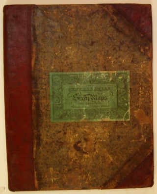
Philadelphia: Anthony Finley, 1824. Atlas. Illustrated with 58 hand colored engraved maps and 2 charts. Small folio (13.5" x 10.75"); publisher's half leather and marbled boards; spine is gilded in 6 compartments, faded; original printed green paper label on cover. Second issue of first edition. All engravings by Young & Delleker. Some wear to edges, minor dampstaining to endpaper and title page. Minor scattered foxing in margins, images mostly unaffected. Severe foxing to map of South America. Owner signature in..... More
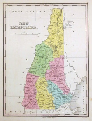
Philadelphia: Anthony Finley, 1824. Map. Engraving with original hand coloring. Image measures 11 1/8" x 8 5/8". Beautiful map of New Hampshire divided into counties. Shows place names, major routes, topographical details and waterways. In maps from this period, New Hampshire was usually bundled together with Vermont. This is an uncommon map exclusively depicting New Hampshire. In very good condition. Minor foxing. Anthony Finley (c. 1790-1840) was a prominent American cartographic publisher in the early 19th century. This map was..... More
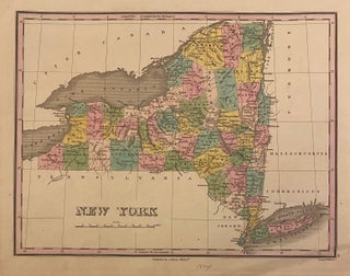
Philadelphia: Anthony Finley, 1824. Map. Engraving with original hand coloring. Image measures 8 1/2" x 11 1/4" Early map of New York state divided into counties. Cities, towns, roads, waterways, islands, geographical features are labeled. In very good condition, with some very minimal spotting, and minor wear to margins not affecting the image. Otherwise clean and bright with extra care taken with the original coloring. Anthony Finley (c. 1790-1840) was a prominent American cartographic publisher in the early 19th century..... More
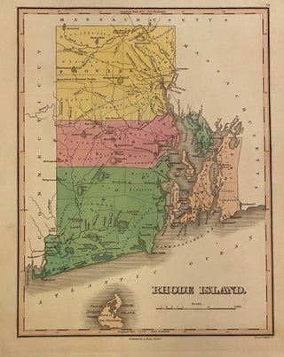
Philadelphia: Anthony Finley, 1824. Map. Engraving with original hand coloring. Image measures 11 3/8" x 8 5/8" Lovely map of Rhode Island divided into counties. Cities, towns, roads, waterways, islands, geographical features are labeled. Notably, some points of interest are also included, such as a ship yard, iron works, bridges, and mills. These sites illustrate the growing industries of the state in the early 19th century. Topography is depicted by hachure. In excellent condition. Anthony Finley (c. 1790-1840) was a...... More
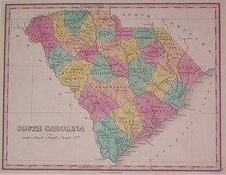
Philadelphia: Finley, Anthony, 1824. Map. Engraving with original hand coloring. Image measures 8.5" x 11.25". Classic map of South Carolina divided into counties. Shows clearly major towns, routes and waterways. Minor toning to edges. Anthony Finley (c. 1790-1840) was a prominent American cartographic publisher in the early 19th century. This map was published in "A New General Atlas", which was well received and praised for its clearness and accuracy. More
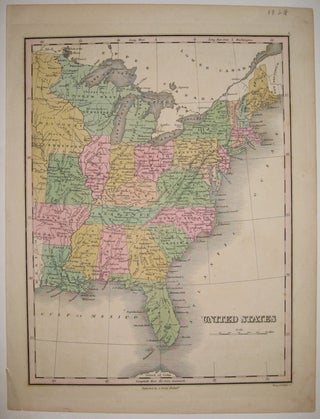
Philadelphia: Finley, Anthony, 1824. Map. Engraving with hand coloring. Image measures 11.25" x 8.5". Great map of the Eastern portion of the United States to Missouri Territory. Shows cities, major routes, topographical details and waterways. Chip to lower left corner. Anthony Finley (c. 1790-1840) was a prominent American cartographic publisher in the early 19th century. This map was published in "A New General Atlas", which was well received and praised for its clearness and accuracy. More
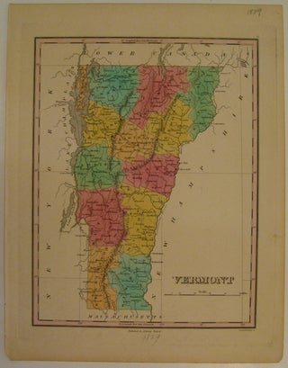
Philadelphia: Anthony Finley, 1829. Map. Engraving with original hand coloring. Image measures 11 1/8" x 8 5/8". Beautiful map of Vermont divided into counties. Shows place names, major routes, topographical details and waterways. Small chip to lower left corner. Light stain to right margin. Anthony Finley (c. 1790-1840) was a prominent American cartographic publisher in the early 19th century. This map was published in "A New General Atlas", which was well received and praised for its clearness and accuracy... More
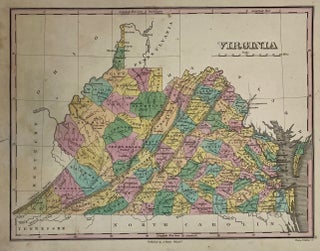
Philadelphia: Finley, Anthony, 1827. Map. Engraving with original hand coloring. Image measures 9" x 11 1/2" inches. A nice map of Virginia and West Virginia, hand colored to show counties. Towns, major routes and waterways are labeled. In very good condition, with one closed tear to left margin not affecting the image. Anthony Finley (c. 1790-1840) was a prominent American cartographic publisher in the early 19th century. This map was published in "A New General Atlas", which was well received..... More
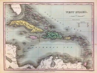
Philadelphia: Anthony Finley, 1824. Map. Engraving with original hand coloring. Image measures 8.5" x 11.25". This lovely 1824 map by Anthony Finley features the West Indies and Caribbean Islands. Extends from southern Florida to northern South America and includes the Bahamas, the Leeward and Windward Islands. Cat Isle in the Bahamas is noted as 'the first land seen by Columbus, 1492'. The map is beautifully detailed and notes the important cities and some topographic features. The map is in good..... More
London: Chatto & Windus, 1986. Illus. 8vo, red cloth, d.w., pages lightly browned throughout in right margins, otherwise fine. London: Chatto & Windus, (1986). Abridged edition with additional material by C. J. H. Duggan. More
Indianapolis: Bobbs-Merrill, 1926. 8vo, black cloth lettered in red. Indianapolis: Bobbs-Merrill, (1926). First Edition. Presentation copy to Charles Hanson Towne, in the form of a six line poem. More
I have just safely received my latest purchase from Argosy Book Store. The packaging for my last two orders has been excellent and I look forward to ordering again soon!
Hi! I have visited your store several times since moving to NYC and I just love it! Excellent work! Thanks so much for your help. You are a charming and delightful part of this grand city and I am so glad to have found you so early in my life here!