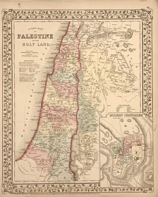
A New Map of Palestine or the Holy Land
Philadelphia: 1869. Map. Engraving with original hand coloring. 14 1/4 x 11 1/2 inches. Early map of Palestine or the Holy Land from the Dead Sea to Lebanon with part of Syria showing the biblical names of the tribes of Israel. Royal cities noted with towns, waterways, and geographical features also labeled. Turkish names noted as well as ruins. An inset of modern Jerusalem is included. In the index a color line should denote 'Land of the Philistines' but it..... More