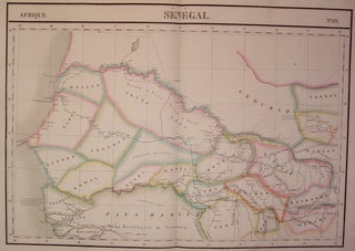
Senegal. Afrique. No. 19
Brussels: Vandermaelen, Phillippe Marie, 1827. Map. Large format lithograph of West Africa with original hand coloring. Image measures 18.5" x 22.25". Includes Senegal and Gambia. Double page with centerfold. From Vandermaelen's 6 volume "Atlas universel de geographie physique, politique, statistique et mineralogique, sur l'echelle de 1/16411836". Can be combined as gores to form an immense globe. The atlas was the first to map the world on a uniform scale. More