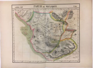
Partie Du Mexique; Amer. Sep. No. 64
Brussels: 1827. Map. Lithograph with original hand coloring. 18" x 21". Beautiful depiction of Western Mexico with a focus on elevation from Mazatlan to Manzanillo -Mexico's busiest Pacific port. Phillippe Marie Vandermaelen (1795-1869) was a Belgian cartographer and publisher. His Atlas universal was both the first lithograph atlas and the first atlas to map the world on a uniform scale. The maps were meant to join together to form a huge globe. This map is a fine example of his..... More