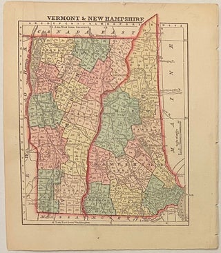
Vermont and New Hampshire
New York: Samuel Gaston, 1857. Map. Engraving with original hand coloring. Image measures 6 1/4 x 5" This map shows the states of Vermont and New Hampshire in the middle of the 19th century. Published in 1857, it shows these states during a time of development and industrialization. The states are divided into hand-colored counties, and the index includes towns, rivers, canals, and both existing and proposed railroads. The northernmost tip of New Hampshire peeks out above the top border..... More
![Item #137410 A Guide through World Chaos. [Edition of 1934]. G. D. H. COLE](https://argosybooks.cdn.bibliopolis.com/images/noimage.png?auto=webp)