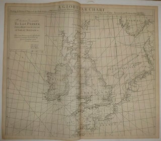
A Globular Chart shewing the errors of Plain, and the Deficiencyes of Mercators Sailing, and Discovering the true Navigation according to the Globe.
London: James Knapton, 1728. Sea Chart. Uncolored engraving. An alternate projection of the globe as a flat map to the prevailing Mercator Projection. Includes rhumb lines and coastal details. From Atlas Maritimus, a commercial sea atlas was published as a guide to British global commerce. Good condition with some stains along lower center fold. Sir Edmond Halley (1656--1742) was an English astronomer, geophysicist, mathematician, meteorologist, and physicist known for computing the orbit of the eponymous Halley's Comet. He was the..... More