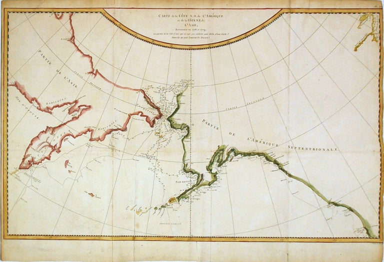
Carte de la Cote N.O. de l'Amerique et de la Cote N.E. de l'Asie, Reconnues en 1778 et 1779. Les parties de la Cote d'Asie qui ne sont pas ombrees sont tirees d'une Carte Manuscrite que nous donnerent les Russea
Paris: Jacques-Francois Benard, 1785.
Map. Engraving with hand coloring. Image measures 15.25" x 26". 1785.
This important map of the North Pacific covers the northwest coast of America including Alaska east as far as the Hudson Bay and the northeast coast of Asia including Kamchatka. Published in French, the map is based on a Russian manuscript map and is the first French edition of the official account of Captain James Cook's Third Voyage in the HMS Revolution between 1778 and 1779. The route of his journey is depicted in detail with depth soundings noted along the route. Several Capes, islands and bays are labeled. This map is among the first to accurately map the coastlines of the region.
It was during this voyage, that Cook encountered an 'impenetrable wall of ice' in the Arctic as he searched for the Northwest Passage, thus putting to rest the hopes for the discovery of an Arctic Northwest Passage. The map is in good condition with minor wear and verso reinforcements along the fold lines and some foxing at places. Right margin trimmed to the neat line.
Jacques-Francois Benard was a publisher and engraver based in Paris active in the mid 18th century. He was the son-in-law and successor (along with William Danet) to Nicolas de Fer after de Fer's death in 1720.
Binding: Unbound
Language: French
Price: $750.00
Item #267584