
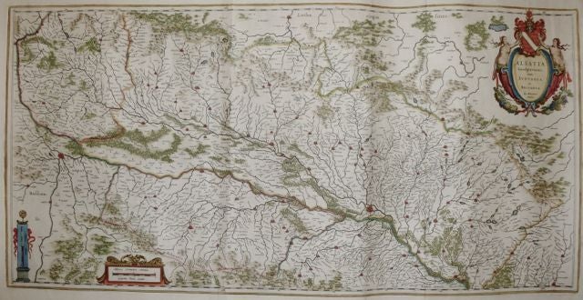
Alsatia Landgraviatus, cum Suntgoia et Brisgoia
Amsterdam.
Map. Copperplate engraving with hand coloring. Image measures 15.5 x 31". Sheet measures 22 x 33".
This map of the historic French region of Alsace focuses on the lower Rhine River. Oriented with north to the right, the map describes a fertile area of France that, due to the many tributaries of the river, has historically been well-known for its wine. Perhaps the lushness of the region can account for the map's, particularly risqué title cartouche, which features two scantily clad women flanking the region's seal. In fact, this image was so indecorous that it led one viewer--perhaps a monk--to censor out the women with black gouache. Professional cleaning, restoration, and enhancement has brought the map back to its intended appearance. Wide top and bottom margins with some tears not affecting the image. Two sheets joined, as issued, with French text on verso. Willem Blaeu (1571-1638) was a prolific Dutch mapmaker who started one of the most famous map publishing firms of the 17th century. It was at this time that the Dutch controlled the map trade, and their ornate and beautiful maps had immense popularity. Blaeu was instrumental in driving this dominance in his lifetime, and this legacy was continued by his sons. Expert repair to center fold and lower left corner chipped. Priced as is.
Binding: Unbound
Language: Latin
Price: $1,100.00
Item #252126