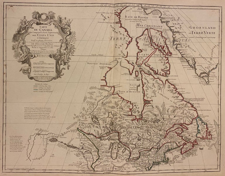
Carte Du Canada Qui Comprend la Partie Septentrionale Des Etats Unis D'Amerique
Dezauche, 1783.
Map. Engraving with hand coloring. Image measures 19.75 x 25.5". Sheet measures 21.5 x 30".
This map of Canada and the northern United States extends north from around the latitude of Baltimore all the way up to Baffin Bay along the shore of Greenland. Published by Jean-Claude Dezuache in 1783, it is the eighth revision of a map originally published by De L'Isle in 1703. The map is notable as the first to include "Etats-Unis" in the title, coming as it did on the heels of the American Revolution. In fact, this appearance is one of the earliest appearances of the name United States (Etats-Unis) on a printed map. The map is compelling in its accuracy, particularly with regard to the Great Lakes, depicting them as fully enclosed and properly placed in longitude and latitude. There is also excellent detail around the Hudson and Mississippi Rivers. The elaborate cartouche is decorated with a beaver, natives (one of whom is bearing a scalp), and Jesuit explorers. Furthermore, the fleurs-de-lis that previously adorned the shield at the top of the cartouche has been erased and the crown converted into a halo suspended above an orb, a response to the execution of the king following the French Revolution Below, a table of colors delineates the boundaries of the United States and European possessions. Indian nations are also labeled. The map is in excellent condition with wide margins as issued. Guillaume De L'Isle (1675--1726) was a French cartographer known for his popular and accurate maps of Europe and the newly explored Americas and Africa. He is important as the first "scientific" cartographer who incorporated the most current information on exploration and topography into his maps. Philippe Buache (1700--1773) was a student of De L'Isle and became one of the most active proponents of the so-called school of theoretical cartography active in mid-18th century France. This map is fascinating record from a remarkable moment in North American history.
Language: English
Price: $2,150.00
Item #242998