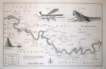
A Map of the River Gambra from Eropina to Barrakunda
London: Thomas Kitchin, 1732.
Pictogram map. Published in London, 1732. Image measures 8" x 12.75".
Beautifully illustrated map of the Gambra (Gambia River), with surrounding settlements, roads, tributaries, and topography. The map, engraved in 1765, is based on Captain John Leach's journals from his voyages in West Africa in 1732. On behalf of the Royal Company of Africa, Leach and Thomas Harrison explored the region for trading opportunities. Trading rights in the region were sold by Portugal to England in 1588. Cities and mountains are rendered pictorially, and depths by soundings are included throughout the river. Surrounding the map are engravings of insects and an ant hill. In very good condition. Original fold lines as issued.
Thomas Kitchin (1719-1784) was an English engraver and map-maker. His maps and atlases of England earned him the position of hydrographer to the King.
Binding: Unbound
Condition: Very Good
Language: English
Price: $300.00
Item #202068